Showing posts with label drone. Show all posts

Monday, February 24, 2014

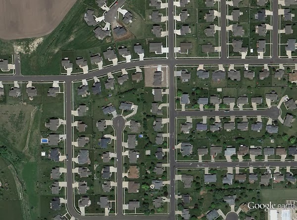
Satellite images show devastating effects of a big tornado on a small Illinois town

before
after

The Nov. 17, 2013 tornado outbreak ended the lives of three people in the town of Washington, Ill., and upended the lives of many in the town of 15,000.

Many news stations released aerial photos of the devastation, but only recently were satellite photos released which gave a new appreciation of the scope of the disaster. As many as 500 homes were damage or destroyed during the tornado outbreak.

Tuesday, December 24, 2013

Missed target, found hooliganism on drone mapping mission

A small unmanned aircraft system for mapping, developed for a National Science Foundation grant to improve STEM education.

In north Louisiana, there’s a fantastic little place known for Muscadine grapes, pecans, and on occasion, alligators.

Muscadines always get turned into jelly; an excellent topping for southern-style biscuits (my wife says she’s still working on mastering the family biscuit recipe, but she’s produced the finest biscuits I’ve ever had the pleasure of eating).

Pecans, a grocery bag of which could fetch a gold bar by northern exchange rates, are so plentiful that they must be given away. They’re so much a part of my wife’s heritage that we decided to get married beneath those pecan trees.

And when the water is high in the backyard bayou, a small alligator sometimes will make itself at home. If the alligator is lovingly cared for and becomes fat, a portion of that alligator eventually will make its way to our dinner table in the form of a delightful alligator sauce piquant (wife insists that it be cooked like shrimp, and not burnt to a crisp as it’s done here in the North).

So before we went down to visit my wife’s family farm for Thanksgiving, I decided to pack up one of the “drones” I’ve developed at the National Science Foundation grant where I work, to see if I couldn’t map out this interesting place.

Saturday, April 13, 2013

Why Google's executive chairman is totally wrong about "drones"

Eric Schmidt
In a interview published in the Guardian newspaper on Saturday, Google Executive Chairman Eric Schmidt called for tough regulations on unmanned aircraft systems, commonly called drones.

The BBC reported that Schmidt said:
"How would you feel if your neighbour went over and bought a commercial observation drone that they can launch from their backyard. It just flies over your house all day. How would you feel about it?"
Schmidt went on to suggest that only governments should have access to unmanned technologies:
"It's got to be regulated... It's one thing for governments, who have some legitimacy in what they're doing, but have other people doing it... it's not going to happen."

Friday, November 9, 2012

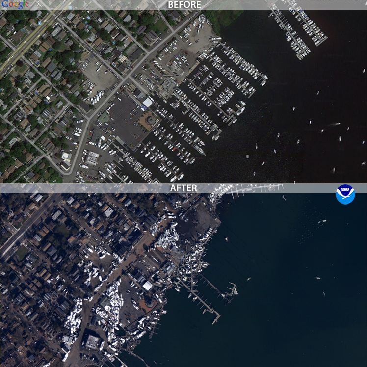
We need more drones because we’re having more big disasters.


The images of an inundated New York City certainly were eye-catching. But it isn’t until you start parsing the data that you start to really understand how bad things got for the East Coast.

Some of the most startling stats: winds pegged at 90 miles an hour when Sandy made landfall as a tropical storm. It left 185 dead between Jamaica and its terminus in the US. It was the second costliest hurricane in recorded history after Katrina, with $52.4 billion in damages. Five thousand commercial airline flights cancelled. Across 26 states, up to 80 million were affected. Eight and a half million people without power after the storm.

Even 11 days after the storm, with freezing winter temperatures closing in, 428,000 in New York and New Jersey remain without power.

Aon Benfield, an insurance broker that specializes in catastrophe management, crunched the numbers and found something just as remarkable about hurricane/tropical storm Sandy. Well, perhaps not so much about the storm itself, but how it fits into recent weather events and climate change in general.

“Devastating Hurricane Sandy was the eleventh billion-dollar weather-related disaster in the U.S. so far this year, and the most expensive,” wrote Wunderground.com’s Jeff Masters, of Aon Benfield’s latest report. “This puts 2012 in second place for most U.S. billion-dollar weather disasters behind 2011, when NOAA's National Climatic Data Center (NCDC) counted fourteen such disasters.”

Meanwhile, climate scientists noted that not only did global warming make such a historic slew of storms possible, it also made the sea level rise, thus increasing the damage to coastal areas.

“Sandy threw the ocean at the land, and because of global warming, there were about eight inches more ocean to throw,” wrote Chris Mooney on The Climate Desk. “As the water level increases, the level of damage tends to rise much more steeply than the mere level of water itself.”

When Thailand was flooded in 2011, the government contracted a drone to scout out where flooding had occurred, which helped make decisions about where and when to release flood gates. The contractor flew more than 60 flights over a period of 45 days, and claimed that the data obtained from those flights helped prevent the city of Bangkok from suffering more during that catastrophe.

That same year, back in the states, freelance journalist and storm chaser Aaron Brodie took sweeping shots of the Jersey Shore with his own multicopter before and after Hurricane Irene. He uploaded this footage on YouTube, but amended his post after Sandy:

“Irene was child's play in comparison to Superstorm Sandy. In fact, there was no real damage from Irene,” Brodie wrote.

The public wasn’t able to obtain coverage from drones for Sandy. Some news sites did, however, post before and after photos of New York and New Jersey. These post-sandy aerial photos were obtained by the National Geodetic Survey, with the help of NOAA’s King Air and Twin Otter remote-sensing aircraft. The photos were set side-by-side with historic satellite imagery, allowing users to drag these images to do their own comparisons.


Because of the prohibitive cost of aerial photomapping, these images were gathered by government agencies. But, if FAA regulations allowed it, the job could have easily been done with a $1,000 aerial drone. That puts it within reach of even independent and backpack journalists. Or concerned members of the community.

If the climate models hold true, there’s going to be more “superstorms” like Sandy every year. There will be more billion-dollar disasters, more lives lost, more power outages, and the public will need more information about how those disasters are affecting their communities.

Drones are especially capable of giving quick data on the scope, or extent, of large-scale disasters. Now is the time for journalists to learn and perfect tools like the drone to give the public that information.

Photo at the top of the post is of post-Sandy flooding in Haiti, via the Flikr photostream of United Nations Stabilization Mission In Haiti.
Friday, March 2, 2012

The Harrisburg tornado, the JournoDrone, and a well-deserved crash

Aerial photograph of Harrisburg, IL. Not taken by JournoDrone One.

Today, the southern Illinois town of Harrisburg is morning six of its own who were killed by a 170 mile per hour, 200 yard tornado. It was one of the 16 tornadoes that ripped through Nebraska, Kansas, Missouri, Illinois and Kentucky, claiming 13 lives.

Tuesday night, while news networks came from far and wide to cover the devastation on the ground, I worked to prepare JournoDrone One to film the disaster from the sky. For better or worse, the drone never made it to Harrisburg.

JournoDone One is a test mule for DroneJournalism.org, which myself and fellow drone journalism developer Acton Gorton hope will pave the way for a low-cost, highly durable and transportable small Unmanned Aerial System (sUAS) for journalists.

JD-01 had never flown a mission before, let alone been tested. So the idea of rushing to Harrisburg and filming anything was a long shot, but something I felt I needed to try. This was a disaster just three and a half hours’ drive from home base, and if I had anything to say about it, I would be putting my equipment to good use. And I do venture to natural disasters on a whim.

Of course, it wouldn’t do any good to drive to the storm-ravaged town of Harrisburg just to nose-dive a drone into the rubble after takeoff. The town had enough grief and did not need some clumsy pilot crashing drones into things and making things worse. So instead, I had a test flight in Champaign, where I dove the drone into a freezing field. Here’s what happened.


Thursday, January 26, 2012

Images from Drone Causes Federal Investigation


In what is possibly the first major exposé initiated through drone technology, a small unmanned craft captured evidence of environmental contamination in Texas.

sUAS News reported that a Dallas drone enthusiast was testing a drone, named “Exposure,” when he captured images of what appeared to be a polluted creek near a meat packing plant.

“I was looking at images after the flight that showed a blood red creek and was thinking, could this really be what I think it is?” he told sUAS news. “Can you really do that? Surely not.”

The hobbyist called a Coast Guard 1-800 number, and state environmental investigators reached the creek 40 minutes after the call.

The Environmental Protection Agency, and several state environmental authorities, executed a search warrant at the Columbia Packing Company on January 19.  A criminal investigation is now underway.

The Fox 4 station in Dallas reported that the plant was still operational during the investigation. Field tests from Texas Parks and Wildlife indicated pig blood and toxic chemicals had been dumped in the plant, according to the Dallas Morning News.

Local news outlets seem to have glossed over the fact that the aerial photos which launched the criminal investigation were taken by a drone, and none seem to have tracked down or interviewed the pilot. Additionally, sUAS News declined to publish the drone pilot’s name, citing concerns about the ongoing investigation.


The pilot’s secrecy may stem from a concern about his own safety and well-being after exposing possible criminal activity (potentially involving persons with power and money). But a commenter in the sUAS story also pointed out that this might also be about the hobbyist protecting his pastime – aerial imagery and drone piloting – from scrutiny and harsh regulation.

The reason for his secrecy may be a combination of both those things, or things yet unpublished. All accounts suggest he was a regular RC pilot, without pretense, who simply stumbled on criminal activity near a Dallas meat packing plant. But this shows exactly what drone journalists are aiming for, and demonstrates what is possible when you combine small, inexpensive airframes with imaging equipment.

Drone journalists, news orgs and nonprofits should make a mental note of this event and learn a thing or two from it. A good way to start a systematic investigative report on the local environment would be to take photos of creeks and tributaries near industrial operations.

Images:
1) Aerial photo of the contaminated creek, ostensibly taken by the drone pilot, as published by DMN in an online photo gallery.
2) The Exposure airframe, which is capable of carrying a DSLR camera.