Showing posts with label UAV. Show all posts

Monday, January 13, 2014

A discussion on deploying drones for international development


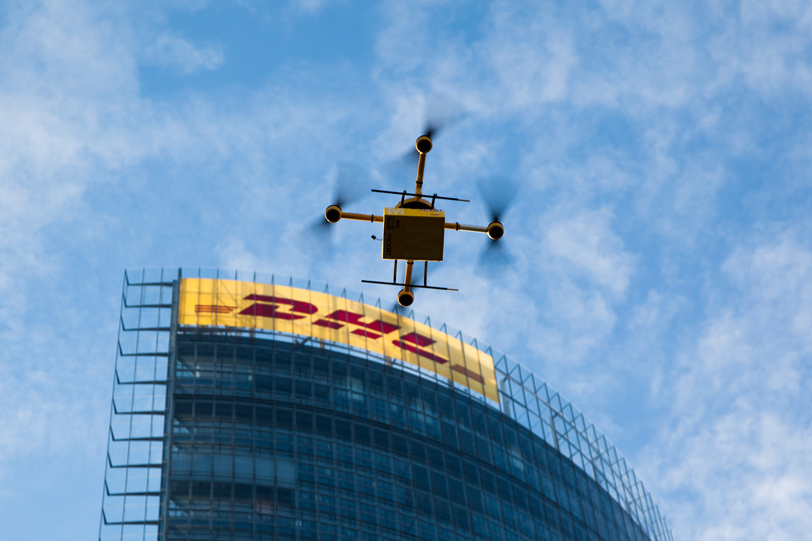
Last month, Deutsche Post DHL transported six kilograms of medicine from a pharmacy in Bonn, across the Rhine River, to its headquarters.

This wouldn't have made international news, except that DHL accomplished this with an unmanned aircraft system - commonly known as a drone.

This came less than a week after Amazon's Jeff Bezos claimed his company would deliver products to customers' doorsteps via drone in three or four years. Regulations  and technological hurdles would make Bezos' plan all but impossible in the US near-term, but DHL proved that with proper planning and logistics, you could deliver small parcels with small drones today.

On January 22, The International Research and Exchange Board, or IREX, will be hosting a "deep dive" discussion on how this same technology could benefit international development.

Monday, November 25, 2013

There's been a big uptick in drone research over the last decade


Recently, I was tasked with producing some basic citations on unmanned aerial vehicles, more commonly called drones, for a new grant proposal. As you could imagine, it was not hard to find a cornucopia of papers reflecting the many novel uses for the technology.

What might surprise some, though, was the sheer increase in drone research, how popular these papers are in the academic world, what that research trying to accomplish, and who was funding it.

Wednesday, January 9, 2013

Droneveillance, and blogging for the International Symposium on Technology and Society


Lately I've found myself blogging for the International Symposium on Technology and Society, or ISTAS. It's an annual conference sponsored by IEEE (the Institute of Electric and Electronic Engineers), which as its name suggests, focuses on the impact that evolving technologies have on everyday life. This year's conference will pay special consideration to the future of the smart infrastructure and surveillance:
In a world of smart things like smart lights, smart toilets, smart grids, smart meters, smart roads, and the like, what happens when you have "smart people" (i.e. put sensors on people)? What do we make of the growing numbers of businesses like department stores and restaurants that prohibit cameras, yet display QR codes that require cameras to read and understand?
It's not just about surveillance, either. Surveillance has a specific meaning, which refers to observing people or objects from an elevated position.That means surveillance is conducted by law enforcements and governments. Sousveillance, on the other hand, means observing or recording from below. When average citizens, as opposed to the government, do the recording, that's sousveillance.

How about droneveillance? Unlike fixed cameras, drones are highly mobile platforms for a variety of remote sensing devices. They're agile, relatively silent (depending on the altitude), and can even fly indoors. They've gotten especially smart at negotiating obstacles and mapping unfamiliar terrain, and they can work as a team to provide comprehensive monitoring.

Friday, November 9, 2012

We need more drones because we’re having more big disasters.


The images of an inundated New York City certainly were eye-catching. But it isn’t until you start parsing the data that you start to really understand how bad things got for the East Coast.

Some of the most startling stats: winds pegged at 90 miles an hour when Sandy made landfall as a tropical storm. It left 185 dead between Jamaica and its terminus in the US. It was the second costliest hurricane in recorded history after Katrina, with $52.4 billion in damages. Five thousand commercial airline flights cancelled. Across 26 states, up to 80 million were affected. Eight and a half million people without power after the storm.

Even 11 days after the storm, with freezing winter temperatures closing in, 428,000 in New York and New Jersey remain without power.

Aon Benfield, an insurance broker that specializes in catastrophe management, crunched the numbers and found something just as remarkable about hurricane/tropical storm Sandy. Well, perhaps not so much about the storm itself, but how it fits into recent weather events and climate change in general.

“Devastating Hurricane Sandy was the eleventh billion-dollar weather-related disaster in the U.S. so far this year, and the most expensive,” wrote Wunderground.com’s Jeff Masters, of Aon Benfield’s latest report. “This puts 2012 in second place for most U.S. billion-dollar weather disasters behind 2011, when NOAA's National Climatic Data Center (NCDC) counted fourteen such disasters.”

Meanwhile, climate scientists noted that not only did global warming make such a historic slew of storms possible, it also made the sea level rise, thus increasing the damage to coastal areas.

“Sandy threw the ocean at the land, and because of global warming, there were about eight inches more ocean to throw,” wrote Chris Mooney on The Climate Desk. “As the water level increases, the level of damage tends to rise much more steeply than the mere level of water itself.”

When Thailand was flooded in 2011, the government contracted a drone to scout out where flooding had occurred, which helped make decisions about where and when to release flood gates. The contractor flew more than 60 flights over a period of 45 days, and claimed that the data obtained from those flights helped prevent the city of Bangkok from suffering more during that catastrophe.

That same year, back in the states, freelance journalist and storm chaser Aaron Brodie took sweeping shots of the Jersey Shore with his own multicopter before and after Hurricane Irene. He uploaded this footage on YouTube, but amended his post after Sandy:

“Irene was child's play in comparison to Superstorm Sandy. In fact, there was no real damage from Irene,” Brodie wrote.

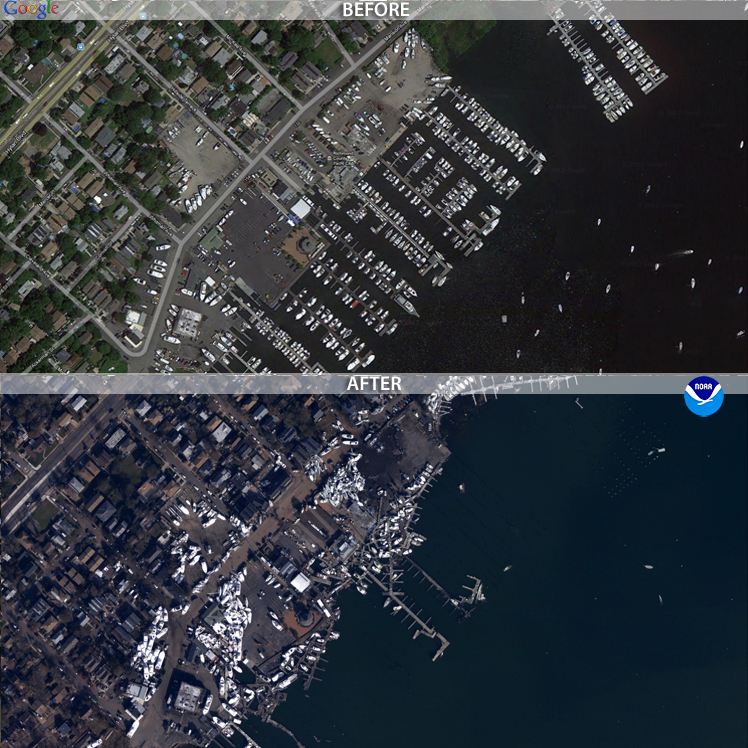
The public wasn’t able to obtain coverage from drones for Sandy. Some news sites did, however, post before and after photos of New York and New Jersey. These post-sandy aerial photos were obtained by the National Geodetic Survey, with the help of NOAA’s King Air and Twin Otter remote-sensing aircraft. The photos were set side-by-side with historic satellite imagery, allowing users to drag these images to do their own comparisons.


Because of the prohibitive cost of aerial photomapping, these images were gathered by government agencies. But, if FAA regulations allowed it, the job could have easily been done with a $1,000 aerial drone. That puts it within reach of even independent and backpack journalists. Or concerned members of the community.

If the climate models hold true, there’s going to be more “superstorms” like Sandy every year. There will be more billion-dollar disasters, more lives lost, more power outages, and the public will need more information about how those disasters are affecting their communities.

Drones are especially capable of giving quick data on the scope, or extent, of large-scale disasters. Now is the time for journalists to learn and perfect tools like the drone to give the public that information.

Photo at the top of the post is of post-Sandy flooding in Haiti, via the Flikr photostream of United Nations Stabilization Mission In Haiti.

Thursday, January 19, 2012

Learning from Crashing in Micro-Drone Journalism


If you are interested in getting started in drone journalism, I highly suggest you first try a small, cheap, indoor RC helicopter equipped with a low-resolution camera.

It will go up into the air, hit something, fall to the ground. And the images will not be great. And sometimes it will just fall over for no apparent reason. And you will fail.

Why choose to fail? Despite how advanced our drone technology has gotten, despite the fact that you can program a microcontroller to automatically fly your helicopter, you still need to understand how things can shake out in the air.


This is my first-ever journalism drone, dubbed “the JournoCopter” by my fiancée. It’s actually a toy called the “Hawk Eye,” and it’s made by the Spinmaster company under the Air Hogs brand of remote-controlled flying toys. They can be found for between $50 and $70 online, but I was fortunate enough to locate this one on clearance at a Target for $41.

The micro-copter operates via a two-channel remote control. That means there are two discreet frequencies that each control a distinct flight characteristic. For this micro-copter, one of the channels is the throttle for the rotors (makes it go up and down), while the other adjusts the speed of the rotors to allow the helicopter to rotate and change direction (left and right).

In addition to the sticks for throttle and direction on the controller, there’s shoulder-mounted buttons for still-frame photography and video. The helicopter can take more than a hundred photos at 640 x 480 (VGA resolution), and about five minutes of video at 320 x 240 (QVGA resolution). To get the photos and videos to a computer, the helicopter docks with the controller, and the controller docks to a computer via USB cable (included). Interfacing with the computer also charges the lithium-polymer battery in the micro-copter. It takes about 25 minutes to charge the micro-copter’s lithium polymer battery from USB.


How does it handle? It doesn’t so much handle as it constantly drifts forward uncontrollably, leaving you to rotate the helicopter so that it doesn’t run into anything. Flying it outdoors is a challenge, as this small copter is influenced by the slightest of winds. And because this micro-copter is controlled via infrared (IR) rather than radio control (RC), much like a television is controlled by an IR remote, direct sunlight will overpower the receiver and sever all communication.

Therefore, it’s best to fly it indoors. However, most people don’t like to be confined in a room with a fast-spinning object that they have no control over. Which brings me back to why this JournoCopter failure is actually a good thing for drone journalism. By experimenting with a small, cheap, finicky drone, you’re going to realize all of the little problems that could manifest themselves as a big problem in a larger, more expensive drone – because all of them will happen to you right from the start.


What do you do when the wind is too strong? How long do you expect the battery to last, and how will you know before it’s too late? Do you know how this flying object is going to behave? The limits of the flying object? Where are the people, and how do you keep a safe distance from them while still getting the shot? Because if worse comes to worse, you need to be prepared to take control and land your drone without harming anyone. You’ll learn these lessons while earning the fine motor skills that you’ll need to pilot a wide variety of craft.


I don’t mean to denigrate this little wonder, either. For less than $100, this company has managed to deliver a remote-controlled helicopter with a two-mode camera, with onboard memory, that can actually fly. Plus, it’s pretty damn indestructible.

But I would, actually, steer aspiring drone journalists to spend just a little more money for a drone that has a smaller failure rate. I cannot vouch for them, but this Egofly LT-712 Spyhawk and this Silverlit SpyCam cost a little more but might offer better control.

The International Journalists Network recently published a list of the top “Five gadgets from CES that are ideal for journalists,” which included two micro-copters for drone journalism. Those might also be worth looking into.

Thursday, May 26, 2011

A Radical New Mission for Drones: Helping Journalists find Truth


Drones are mostly associated with the ongoing war in Afghanistan and Pakistan – where they continue to shoot missiles and drop bombs on the insurgency. Between 1,492 and 2,378 died from drone attacks in Pakistan between 2004 and May 24, 2011, according to theNew America Foundation, and the number of drone attacks have more than doubled under the Obama administration.

The drones present serious concerns for the Pakistanis about their own safety and sovereignty, and have sparked protests at the UK parliament.

The military-industrial complex and global politics have greatly advanced both the application and development of military drones, or Unmanned Aerial Vehicles (UAVs), as they’re called in military parlance. A large, jet-powered stealth drone played a majorrole in tracking down Osama bin Laden. Now there’s entire military expos dedicated solely to UAVs.

But armed conflict and espionage are not a drone’s raison d'être. Strictly speaking, a drone is simply an unmanned vehicle that guided remotely, or is self-guiding. And just as the advancement of drone technology has increased the military’s capabilities, those advancements have trickled down to the private commercial sector.

With a little know-how, a resourceful civilian – or journalist -- can order “off-the-shelf” components and make and fly a drone.